Book of Mormon Geography
I’ve been making notes on Book of Mormon geography for the purpose of making an extended analysis of it. I’ve got a 30 page Word doc now documenting the BOM verses that cover the geography, along with summaries of various theories. It’s very interesting to me, but I haven’t taken the time to put it all together.
The three main theories are
1. LGT model in Mesomerica
2. Heartland model in the US midwest
3. Hemispheric model covering the entire North and South America continents.
I’ll put this post here now as a placeholder for the future to come back to.
I believe the hemispheric model is what the Book of Mormon author intended to convey. I don’t think it’s perfectly consistent with the text. The main issue being the distance between Nephi and Zarahemla which is documented in the text. But I think all the models have problems and this is most accurate, in terms of what the author meant. I am purely looking at this from an internal textual basis, with no weight given to historical and scientific evidence not contained within the text of the Book of Mormon.
I believe the Book of Mormon is scripture, the Word of God. Its message is a powerful witness of Christ and has been transformative in millions of lives, including my own and many others I have seen first hand. I don’t believe it is historical, but I believe it is miraculous, inspired, and inspiring. It’s consistent and complex in many ways. The geography is an important part of that complexity.
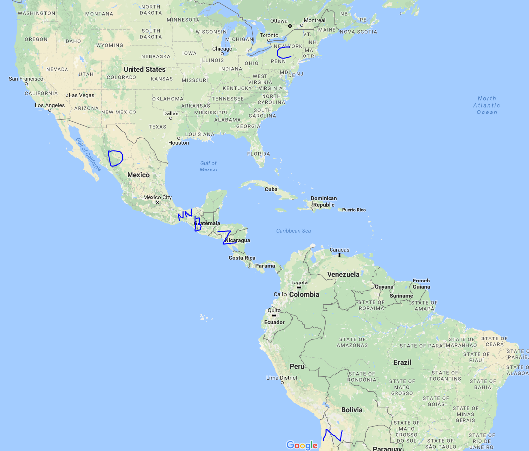
I think this is most likely what is intended. I think the narrow neck is clearly intended to be the Isthmus of Panama, with South America as Lamanite country and North America as Nephite territory. Jaredites also were North America. The Pueblos are in the right spot. The distances don’t make perfect sense, but they’re reasonable. A ship is required to send timber up to the barren north Mexico-southwestern US area, because of the long distance. Only one Cumorah.

C = Cumorah
D = Desolation
NN = Narrow Neck
B = Bountiful
Z = Zarahemla
N = Nephi
But then I found this map from 1796.

In this map, the Isthmus of Panama is just about equal to the narrow neck of land of the Isthmus of Tehuantepec in Mexico. Before the Panama Canal was built in the early 1900’s, the Isthmus of Tehuantepec might have been the higher profile ‘narrow neck’ in Central America. One of the weaknesses of the model is the distance to Cumorah, so this alleviates that a little, so this map is also an alternative.
Heber Frank
You should also consider the Andes with the Amazon basin underwater before Christ model. Start here: https://goo.gl/fP1yCS This is the first of 33 posts overseeing this model. To go to the next blog post, use the Menu on the right side of the webpage.